|
INCLINE PRESS 2 Townsend St., 2-213 San Francisco, CA 94107 (415) 284-0127 |
|||||||||||||||||
|
|
|||||||||||||||||
|
|
|||||||||||||||||
|
|||||||||||||||||
|
SAN FRANCISCO PHOTOS |
|||||||||||||||||
|
|
|||||||||||||||||
|
|
|||||||||||||||||
|
|||||||||||||||||
|
|
|||||||||||||||||
|
|||||||||||||||||
|
|
|||||||||||||||||
|
|||||||||||||||||
|
|
|||||||||||||||||
|
|||||||||||||||||
|
|
|||||||||||||||||
|
|||||||||||||||||
|
|
|||||||||||||||||
|
|||||||||||||||||
|
|
|||||||||||||||||
|
|||||||||||||||||
|
|
|||||||||||||||||
|
|||||||||||||||||
|
|
|||||||||||||||||
|
|||||||||||||||||
|
|
|||||||||||||||||
|
|||||||||||||||||
|
BOOKS |
|||||||||||||||||
|
|
|||||||||||||||||
|
|
|||||||||||||||||
|
|||||||||||||||||
|
|
|||||||||||||||||
|
|||||||||||||||||
|
|
|||||||||||||||||
|
|||||||||||||||||
|
|
|||||||||||||||||
|
|||||||||||||||||
|
|
|||||||||||||||||
|
|||||||||||||||||
|
|
|||||||||||||||||
|
|||||||||||||||||
|
|
|||||||||||||||||
|
|||||||||||||||||
|
|
|||||||||||||||||
|
|||||||||||||||||
|
|
|||||||||||||||||
|
|||||||||||||||||
|
|
|||||||||||||||||
|
|||||||||||||||||
|
|
|||||||||||||||||
|
|||||||||||||||||
|
|
|||||||||||||||||
|
|||||||||||||||||
|
|
|||||||||||||||||
|
|||||||||||||||||
|
NON-SAN FRANCISCO PHOTOS |
|||||||||||||||||
|
|
|||||||||||||||||
|
|
|||||||||||||||||
|
|||||||||||||||||
|
|
|||||||||||||||||
|
|||||||||||||||||
|
|
|||||||||||||||||
|
|||||||||||||||||
|
|
|||||||||||||||||
|
|||||||||||||||||
|
|
|||||||||||||||||
|
|||||||||||||||||
|
OTHER STUFF |
|||||||||||||||||
|
|
|||||||||||||||||
|
|
|||||||||||||||||
|
|||||||||||||||||
|
||||
|
|
||||
|
|
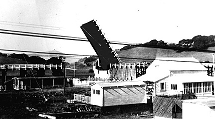
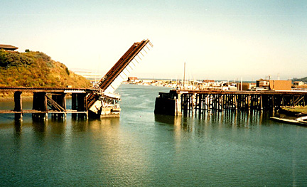
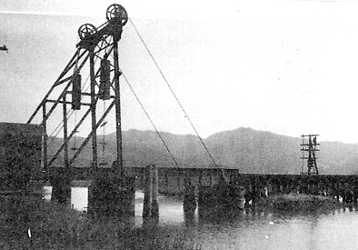
  Shown above, is the original bascule drawbridge over Corte Madera Creek. Photo: Caltrans. Corte Madera Creek originates in the Marin County foothills, winds its way down through Ross, Kentfield and Corte Madera, where it is joined by the tridal water before entering the bay near San Quintin. Whaling ships and schoones used to tie up at Kent and Ross Landings, but lumbering denuded the hills of trees and winter rains sent the soil pouring down into the creek. By 1869, the creek was so silted in it was difficult for ships to reach Ross anymore. Some ships became stuck in the mud and never got out. A few were made into permanent homes and were later joined by new homes built on stilts over the mud. Together they were the subject of controversy for many years. Even today there are some houseboats and stilt houses on the marshes at the mouth of the creek. The first highway drawbridge to span Corte Madera Creek was a hand-operated, wooden bascule bridge built in 1917. It was located just west of the existing railroad bridge (permanently raised) and east of the present freeway overpass. Prior to its construction, traffic crossed the creek three-plus miles to the west. This bridge was removed in 1930, leaving only a short trestle section to serve as a public a fishing pier.  The new highway drawbridge over Corte Madera Creek at Greenbrae Junction in c1930. The view is looking west. Photo: Caltrans. This new $157,000 steel bascule bridge had an 84-foot moveable leaf, 44-foot roadway and one five-foot sidewalk. Since the old bridge was a single-lane structure , one can imagine the celebration when this one opened. Once navigable for at least four miles above its mouth, by the time this bridge was built, it was too shallow, for most boats that were big enough to need the bridge opened. As a consequence, it seldom opened. It was removed on July, 29,1960, shortly after the present high-level structure was opened for traffic.  The Northwestern Pacific Railroad drawbridge at Greenbrae — a familiar sight to Marin County commuters The original drawbridge at this location was constructed by the Tiburon and San Rafael Railroad in 1884. The one shown in the photo above, was built in 1924 by the Northwestern Pacific Railroad. Not having felt the weight nor heard the sound of a train since the 1960s, this "abandoned" bridge is maintained in the open position with its 61-foot leaf reaching skyward. Currently owned by the Golden Gate Bridge District, it's future is uncertain. In the early years, prisoners were brought here by train and transferred to horse drawn wagons for delivery to San Quentin. This bridge's moment of fame came as a bit part in the Clint Eastwood movie, Dirty Harry.  This c1917 photo shows the third and last drawbridge to span Gallinas Creek. It was located within sight of the Marin County Civic Center in San Rafael. Gallinas Slough (later Gallinas Creek) is a mostly tidal stream that flows into San Pablo Bay via the Santa Venitia Marsh, northeast of San Rafael. In 1879, the San Francisco & North Pacific Railroad built a manually-operated wooden swing bridge over the slough approximately two miles from its mouth. It was replaced in 1911, by another wooden bascule bridge, also hand-operated. By 1917, that bridge had worn out — not by opening and closing — but by the trains crossing the flimsy structure. The 1917 bridge, the last one to span the shallow waterway, was the steel counterweighted bascule bridge shown above. Removed c1947, it, like the others before it, seldom opened for water traffic.  North Bay Bridges #1 Carquinez Strait (Martinez), Pacheco Slough (Martinez), Montezuma Slough (Chipps Island), Napa River (Napa). North Bay Bridges #2 Napa River (Napa), (Brazos), (Vallejo). North Bay Bridges #3 Napa River (Mare Island), Sonoma Creek, Tolay Creek (Sears Point Toll Road). North Bay Bridges #4 Petaluma River (Grandview), (Black Point), (Haystack Landing), ("D" Street), (Washington Street). North Bay Bridges #5 Novato Creek (Bel Marin Keys), Richardson Bay (Sausalito), Corinthian Inlet (Belvedere-Tiburon). |
|
||