
|
INCLINE PRESS 2 Townsend St., 2-213 San Francisco, CA 94107 (415) 284-0127 |
|||||||||||||||||
|
|
|||||||||||||||||
|
|
|||||||||||||||||
|
|||||||||||||||||
|
SAN FRANCISCO PHOTOS |
|||||||||||||||||
|
|
|||||||||||||||||
|
|
|||||||||||||||||
|
|||||||||||||||||
|
|
|||||||||||||||||
|
|||||||||||||||||
|
|
|||||||||||||||||
|
|||||||||||||||||
|
|
|||||||||||||||||
|
|||||||||||||||||
|
|
|||||||||||||||||
|
|||||||||||||||||
|
|
|||||||||||||||||
|
|||||||||||||||||
|
|
|||||||||||||||||
|
|||||||||||||||||
|
|
|||||||||||||||||
|
|||||||||||||||||
|
|
|||||||||||||||||
|
|||||||||||||||||
|
|
|||||||||||||||||
|
|||||||||||||||||
|
BOOKS |
|||||||||||||||||
|
|
|||||||||||||||||
|
|
|||||||||||||||||
|
|||||||||||||||||
|
|
|||||||||||||||||
|
|||||||||||||||||
|
|
|||||||||||||||||
|
|||||||||||||||||
|
|
|||||||||||||||||
|
|||||||||||||||||
|
|
|||||||||||||||||
|
|||||||||||||||||
|
|
|||||||||||||||||
|
|||||||||||||||||
|
|
|||||||||||||||||
|
|||||||||||||||||
|
|
|||||||||||||||||
|
|||||||||||||||||
|
|
|||||||||||||||||
|
|||||||||||||||||
|
|
|||||||||||||||||
|
|||||||||||||||||
|
|
|||||||||||||||||
|
|||||||||||||||||
|
|
|||||||||||||||||
|
|||||||||||||||||
|
|
|||||||||||||||||
|
|||||||||||||||||
|
NON-SAN FRANCISCO PHOTOS |
|||||||||||||||||
|
|
|||||||||||||||||
|
|
|||||||||||||||||
|
|||||||||||||||||
|
|
|||||||||||||||||
|
|||||||||||||||||
|
|
|||||||||||||||||
|
|||||||||||||||||
|
|
|||||||||||||||||
|
|||||||||||||||||
|
|
|||||||||||||||||
|
|||||||||||||||||
|
OTHER STUFF |
|||||||||||||||||
|
|
|||||||||||||||||
|
|
|||||||||||||||||
|
|||||||||||||||||
|
||||
|
|
||||
|
|
 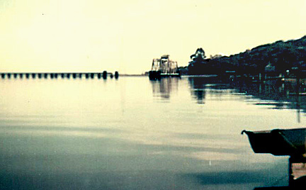 The Northwestern Pacific bridge on the Petaluma River. Built in 1911, this swing bridge replaced an older one built in 1888. Located .8 miles from the mouth of the Petaluma River, it is maintained in the open position. 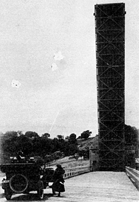 The Black Point Drawbridge over the Petaluma River. Photo: California State Library. This east-looking view of the underside of the open Black Point bascule bridge gives one a good idea of its size. Positioned on the Marin-Sonoma County line, it shortened, by many miles, the distance between most Marin County points and locations in Solano and Napa Counties. So finely balanced, the 650-ton leaf of this Strauss bascule bridge could be moved with one hand when its gears were disengaged. In actual use, two 25 hp electric motors raised and lowered the leaf. This bridge opened to traffic on June 14, 1917 and served for 41 years before being replaced by a concrete high-level bridge in 1958. 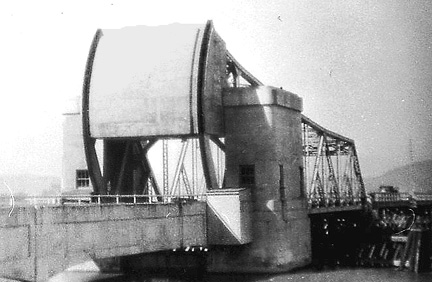 Black Point Bridge. Photo: Shirley Ghiselli Coleman. The west side of the Black Point bridge showing its huge counterweight and operator's house. All water traffic going up the river had to pass through this bridge. It was in use from 1917 to 1958.  Petulama Landing c1915. Photo: San Francisco Maritime Museum. Petaluma has been the head of navigation on the Petaluma River since the beginning of commerce on the river. Until 1961, however, when the 86th Congress changed its name, the waterway was officially Petaluma Creek. At one time Petaluma River was the state's second most important river in terms of tonnage carried. In 1911, it was also the state's third most important inland port. In the year 1896, shipping on the "Creek," as it was called, amounted to nearly $11.5 million. Ferry service between Petaluma and San Francisco spanned nearly 100 years (1852 to 1950). 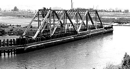 Haystack Landing bridge (N.W. P. R. R.) The above swing bridge belonging to the Northwestern Pacific Railroad was built in 1904 to replace a similar span constructed in 1875 by the San Francisco and North Pacific Railroad. For several years now, this bridge has been maintained in the open position because rail service over the bridge has been discontinued indefinitely. The bridge has only one draw, meaning boats can only pass on one side, and it allows only a skimpy 68 feet of clearance. Back in the1960s, when it had to open for watercraft, it opened on the average of nearly 1500 times a year. That number might not be so different today, if it still had to open. 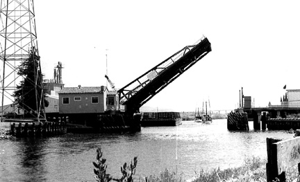 The existing "D" Street bascule bridge from upriver. The original structure at this location was a manually operated iron and wood swing bridge constructed in 1883. During its 50 years of service, it was struck many times by all manner of water vessels and had more than its share of mechanical problems to boot. Declared obsolete in 1920, it limped along for 13 more years before it was removed. Built in 1933, the existing "D" Street Bridge, which reportedly opens 1400 times a year, is among the busiest in the state. The Petaluma River, with its winding course and pastoral scenery is a pleasant trip for boaters, and Petaluma has become a destination for several boating groups. There are also many fishing and pleasure boats berthed in the marina in the center of the city. The Washington Street Bridge from upriver. Photo: Caltrans. Although Petaluma probably could have gotten along just fine without a moveable bridge at this location, it was built anyway. One of California's earliest drawbridges was constructed on this same spot in 1857. The little wood and iron swing bridge was built by real estate developers to get potential customers across the river to their land. That bridge was washed out a year or two later and it is not known just when it was replaced. By 1864, however, a new wooden swing bridge, built at a cost of $823, occupied the spot. It lasted until 1914. The bridge pictured above, a double leaf bascule bridge, was dedicated on August 29, 1914. While it didn't have to open often, it did give the residents something to talk or argue about, and was part of the Petaluma scene until 1970. Although of modern design, the bridge was manually operated for most, if not all, of its 56 years of existence. North Bay Bridges #1 Carquinez Strait (Martinez), Pacheco Slough (Martinez), Montezuma Slough (Chipps Island), Napa River (Napa). North Bay Bridges #2 Napa River (Napa), (Brazos), (Vallejo). North Bay Bridges #3 Napa River (Mare Island), Sonoma Creek, Tolay Creek (Sears Point Toll Road). North Bay Bridges #6 Corte Madera Creek (Corte Madera), (Greenbrae), Gallinas Slough (San Rafael), Gallinas Creek (San Rafael). 
|
|
||