
|
INCLINE PRESS 2 Townsend St., 2-213 San Francisco, CA 94107 (415) 284-0127 |
|||||||||||||||||
|
|
|||||||||||||||||
|
|
|||||||||||||||||
|
|||||||||||||||||
|
SAN FRANCISCO PHOTOS |
|||||||||||||||||
|
|
|||||||||||||||||
|
|
|||||||||||||||||
|
|||||||||||||||||
|
|
|||||||||||||||||
|
|||||||||||||||||
|
|
|||||||||||||||||
|
|||||||||||||||||
|
|
|||||||||||||||||
|
|||||||||||||||||
|
|
|||||||||||||||||
|
|||||||||||||||||
|
|
|||||||||||||||||
|
|||||||||||||||||
|
|
|||||||||||||||||
|
|||||||||||||||||
|
|
|||||||||||||||||
|
|||||||||||||||||
|
|
|||||||||||||||||
|
|||||||||||||||||
|
|
|||||||||||||||||
|
|||||||||||||||||
|
BOOKS |
|||||||||||||||||
|
|
|||||||||||||||||
|
|
|||||||||||||||||
|
|||||||||||||||||
|
|
|||||||||||||||||
|
|||||||||||||||||
|
|
|||||||||||||||||
|
|||||||||||||||||
|
|
|||||||||||||||||
|
|||||||||||||||||
|
|
|||||||||||||||||
|
|||||||||||||||||
|
|
|||||||||||||||||
|
|||||||||||||||||
|
|
|||||||||||||||||
|
|||||||||||||||||
|
|
|||||||||||||||||
|
|||||||||||||||||
|
|
|||||||||||||||||
|
|||||||||||||||||
|
|
|||||||||||||||||
|
|||||||||||||||||
|
|
|||||||||||||||||
|
|||||||||||||||||
|
|
|||||||||||||||||
|
|||||||||||||||||
|
|
|||||||||||||||||
|
|||||||||||||||||
|
NON-SAN FRANCISCO PHOTOS |
|||||||||||||||||
|
|
|||||||||||||||||
|
|
|||||||||||||||||
|
|||||||||||||||||
|
|
|||||||||||||||||
|
|||||||||||||||||
|
|
|||||||||||||||||
|
|||||||||||||||||
|
|
|||||||||||||||||
|
|||||||||||||||||
|
|
|||||||||||||||||
|
|||||||||||||||||
|
OTHER STUFF |
|||||||||||||||||
|
|
|||||||||||||||||
|
|
|||||||||||||||||
|
|||||||||||||||||
|
||||
|
|
||||
|
|
 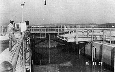 This private, retractable drawbridge spans a navigation lock at the end of Bel Marine Keys Boulevard near Ignacio. Photo: U.S. Coast Guard. Bel Marin Keys, a 1600 + acre water oriented residential community is situated below the high water level of Novato Creek where it is protected by a system of dikes. The moveable bridge makes it possible for boats to enter the 60-foot lock unimpeded while still allowing emergency and farm vehicles to reach the levee road beyond. One of only two retractable drawbridges in California, it was completed in 1985 and is owned by the Bel Marin Development Corp. The vertical clearance under the bridge when in the closed position ranges from 9.8 feet at MLLW to 4.5 feet at MHW. It is maintained in the open position, however, and closed only when a vehicle has to cross the lock. The first drawbridge to span Novato Creek was built by the San Francisco and North Pacific Railroad in 1888. It reportedly spanned the creek about a half-mile south of the Novato train depot. Replaced in 1917, the new one remained there as a drawbridge until at least 1925. It was later reclassified as a fixed span. The same railroad constructed at least three more drawbridges, all bascule spans. across Novato Creek between 1878 and 1917. In March of 1918, a small wooden bascule highway bridge was built over Novato Creek on Highway 37, about 3/4-mile east of Highway 101. Manually operated, it was in place until 1929, when it was removed or converted to a removeable-span bridge. This bridge was within sight of and parallel to, one of the SFNWP bridges mentioned above. 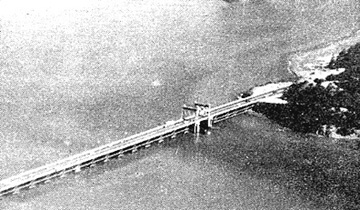 Above is an aerial view of the bascule bridge that spanned a section of Richardson Bay from 1931 to 1956. The view is to the northwest. Photo: U.S.Coast Guard.. While the bridge itself, ended a nighmare traffic situation that had bottled up southern Marin County for years, it is questionable whether or not the moveable span was ever necessary. During one 18-year period, 1931-1949, the bridge was only required to open six times. Three of those openings were for U.S. Corps of Engineers dredges. 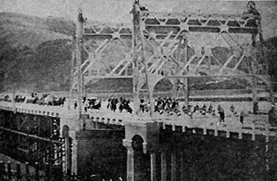 Opening day on the Richardson Bay Bridge (Redwood Bridge," November 22, 1931. Photo: Caltrans. Except for the concrete and steell lift span and piers, the bridge was made entirely of redwood, hence the name, "Redwood Bridge." Until this bridge was completed, all north and south traffic between the Sausalito ferry and San Rafael, followed a circuitous route around the western edge of Richardson Bay causing considerable congestion. The crowd on the bridge was also celebratng the opening of the first hard surface road between Tamalpias and the Marin beaches (Highway 1). After the bridge dedication, a parade of cars proceeded over the new highway to Stinson Beach for a picnic. 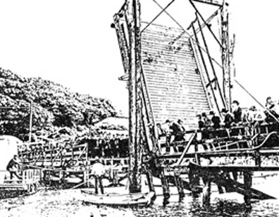 This sketch shows the season opening of the original, wooden bascule bridge over Corinthian Inlet c1900. Photo: Belvedere-Tiburon Landmarks Society. The above bridge was built in 1888, by a Mr. Isreal Kashow. Mr Kashow arrived at Belvedere in 1855 and settled on Belvedere (then called Still Island). Calling it Kashow Island he tried every trick he could think of to make it into an actual island and detach it from the Reed grant. He lost the battle to make it a separate island and, hopefully to gain possesion of it, but he didn't come out too badly. He ended up with deeds to 139 acres of tidelands that included the 28-plus acre lagoon north of Beach Road and much of Corinthian Island itself. He built the bridge across the tidal canal (Corinthian Inlet) that separated Beach Road from Corinthian Island. Each fall, numerous boats, arks and yachts of all sizes moved from their anchorages in Belvedere Cove to the safety of the lagoon. The parade of boats out of the lagoon in the spring marked the opening of yachting season and was the forerunner of today's "Opening Day on the Bay celebration." This bridge was replaced by a similar span in 1912. A wooden bascule bridge with a 30-foot draw, it too, was manually operated and was built as part of the county road. Old timers who remembered the bridge called it the "Hell Gate Bridge." By 1930, the bridge was gone and the lagoon was landlocked.  North Bay Bridges #1 Carquinez Strait (Martinez), Pacheco Slough (Martinez), Montezuma Slough (Chipps Island), Napa River (Napa). North Bay Bridges #2 Napa River (Napa), (Brazos), (Vallejo). North Bay Bridges #3 Napa River (Mare Island), Sonoma Creek, Tolay Creek (Sears Point Toll Road). North Bay Bridges #4 Petaluma River (Grandview), (Black Point), (Haystack Landing), ("D" Street), (Washington Street).
|
|
||